Growth Management
Planning Bend: for us, by us.
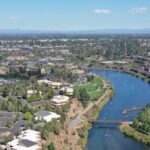
Guiding growth for generations to come.
Planning for the future is a key part of what the City of Bend does. Learn more about how long-range planning for Bend’s growth works below. Information may also be found in the Growth Plan Packet.
Get Started
Be Part of the Plan
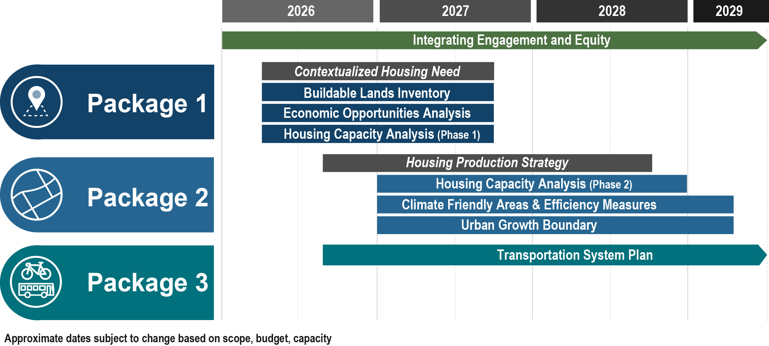
Did you know the City is gearing up to start a multi-year public process to plan Bend’s next 20 years? This growth plan will determine how and where Bend will grow to accommodate our future population and their needs like housing, jobs, schools, parks and more.
This plan will take place over the course of 4-5 years. Here’s what to expect:
The year 2026: Focus will be on staff doing technical data work to get started, researching questions like “How many housing units are needed to meet state requirements?” and “What land is developable and for what uses?” Some public outreach will begin.
The year 2027: Public outreach and engagement will increase. This will be a great time to get involved to give your input on how and where Bend should grow! This is also the earliest a conversation will start about land being potentially brought into the urban growth boundary.
The years 2028-2029: More community engagement will take place. This timeframe will also likely be when the Bend City Council starts making key decisions related to the growth plan.
On January 26, 2026, a presentation about the Growth Plan was given to the Planning Commission. It may be found on the City’s YouTube page. A presentation was also given to City Council on July 16, 2025, and may be found on the City Council Meetings, Agendas, and Videos webpage in the tab labeled 2025 under the Council Meeting Information and Archives section. The presentation begins at approximately 37:00.
Have more questions? Visit our webpage “What is the Plan for Bend’s Growth” for more in-depth info or email us at growthmanagement@bendoregon.gov.
How is growth managed?
Oregon is different from most states because it requires cities to plan for future population and job growth inside an urban growth boundary (UGB). A UGB is an invisible line around a city that helps protect farm and forest land.
Cities can grow in two main ways:
- Growing up: This means building more within the current city limits. It includes taller buildings, denser housing, and mixed-use buildings that combine homes and businesses. It also includes reusing older buildings or land for new, more urban uses. Growing up saves land, protects natural resources, and allows opportunities for additional homes and jobs closer to the city center.
- Growing out: This means expanding the UGB. Adding land to the UGB provides space for additional housing, jobs and complete communities. It also allows for a variety of uses over time to have more convenient and enjoyable neighborhoods.
Through public engagement, the community provides input on how and where Bend grows. That input informs Bend’s Comprehensive Plan. This plan becomes local law and impacts how and where things get built over time.
Historic Imagery Viewer
Wondering where growth in Bend has happened over the past several decades? The Historic Imagery Viewer is an interactive map comparing where and how Bend has grown between 1995 and 2022. What was Bend like in 1995 where you live, work, shop or play today?
To learn more about how and where the City is planning for the next 20 years of growth, visit What is the Plan for Bend’s Growth?
What is the current plan for growth?
What does it take to actually plan for growth? Planning for the future considers a number of impacts on a community. These include how growth will influence the location and number of housing units, our water and sewer systems, how we get around town, future job opportunities and more.
In 2016, the City adopted the Comprehensive Plan which created a clear vision for Bend by the year 2028. This plan is being implemented over time to achieve its policy goals. Policy goals include creating more diverse housing options, identifying land to support economic development, and “wisely growing up and out”.
Planning for Housing
One of the City’s main roles is to make sure Bend has land to meet the needs of our existing and future residents for the next 20 years.
-
Housing: The Comprehensive Plan identified a need for 17,234 new housing units by 2028. We’re on track to meet our adopted housing target goals but we know, based on updated estimates, more housing is needed.
-
Housing choice: The plan calls for a diversity of housing choices for people, from single-family detached homes to townhomes, apartments and condos. A detailed study adopted in 2016 provides more information regarding Bend’s policies to provide more housing choices, affordability and capacity.
-
What’s next: In the coming years, the plan will be updated to make sure Bend has enough capacity for the next 20 years of housing need.
Explore Bend’s Housing Production Dashboard, or recent housing trends in these dashboards.
Planning for Complete Communities
Planning for the future doesn’t just mean accounting for new housing but thinking thoughtfully about how and where housing will be built in relation to other amenities.
-
Complete communities have varied housing options and many of the essential amenities needed for daily living. These include schools, parks and open spaces, shops and services, all within a convenient walking or biking distance.
-
These vibrant areas have safe and accessible transportation options so that residents do not need to rely on a car.
-
In 2016, the Comprehensive Plan established a vision where 86% of Bend residents will live within a 1/2 mile of shops, restaurants and other amenities by 2028. About 99% will live within a 1/2 mile of parks and trails and 60% will live within a 1/2 mile of schools.
Read a more detailed report and analysis of Bend’s urban form in Appendix M, the Urban Form Report.
Planning for Transportation
As our city continues to grow, transportation planning efforts will focus on creating complete communities. Complete communities are where neighborhoods and commercial districts are linked through more walkable and bikeable connections.
- The focus will be on connecting business, houses, parks and schools with safe routes to walk, bike and take transit. It will also recognize the continued need for cars and freight transport.
- Bend will also focus less on car-oriented projects. This shift will save money, offer more transportation options for those who can’t drive or afford a car, and help reduce carbon emissions.
- Transportation projects will prioritize improving safety, connectivity, and accessibility for all modes of travel.
Find out more details about Bend’s transportation plan and city transportation projects.
Planning for Employment
Growth doesn’t just mean planning for housing. It also means making sure plans encourage and accommodate creating new jobs to support a larger population. We’re planning to have enough space for more than 60,000 jobs in Bend by 2028.
- That means planning for accessible commercial and mixed-use lands for businesses serving residents and visitors. It also means planning for industrial and mixed-employment lands for businesses producing new products and services.
- Plans also consider water, sewer and transportation infrastructure to support all businesses in Bend.
Explore Appendix E: Economic Opportunities Analysis to learn more about how the City plans for employment.
Planning for Climate and Resilience
Planning for future growth also means considering how we manage water. Learn more about what the City is doing to conserve water and plan for the future.
- Climate Friendly and Equitable Communities (CFEC) is a set of state rules that aim to encourage cities to develop to be less car-dependent. Climate Friendly Areas (CFAs) are one component of the CFEC rules.
- A CFA is a neighborhood where residents can live, work and meet most of their daily needs without using a vehicle. Designing neighborhoods like this helps lower carbon emissions. CFAs support City Council goals related to the Community Climate Action Plan.
For more information on planning for climate and resilience, visit the CFEC and CFA webpages.
Get Involved with Planning Bend’s Future
There are many ways to get involved in land use and transportation planning in Bend:
- Get involved with a City committee or commission
- Get involved with your Neighborhood District
- Attend a Planning Commission meeting
- Attend a City Council meeting and provide public comment
- Attend a meeting or event listed on the City’s Meetings and Events calendar
- Subscribe to the City’s enewsletter to stay informed about land use, housing or transportation
Have you heard about a project in town and want to be involved but you’re not sure where to start?
Current Planning division – a good resource to learn more about what is happening in and around Bend right now.
Historic Imagery Viewer – this tool compares development in Bend in 1995 to development in 2022. What was your neighborhood like in 1995?
Explore the information below to learn what areas of Bend are changing the most.
Growth Areas: The Core Area has been identified by the community for more urban-scale development.
- Bend Central District: Opportunity for the 3rd Street commercial strip to become a mixed-use area
- KorPine: Opportunity to transform an industrial area into a mixed-use district
- Inner Highway 20 / Greenwood: Opportunity to shift to a more walkable mixed-use area
- East Downtown: Long-term opportunity for an extension of downtown
- Century Drive area: A key part of the Central Westside Plan
Major Projects:
- Midtown crossings
- OSU-Cascades campus expansion
- Major housing and mixed-use projects
Growth Areas:
- Shevlin Expansion Area
- West Expansion Area
- 14 acres mixed employment, 7 acres commercial (near Miller Elementary School), 225 acres residential
- 650 residential units
- 40 acres new public park
Major Projects:
- Discovery Park
- Skyliners Road / Skyline Ranch Road roundabout
- Skyline Ranch Road from Skyliners Road to Shevlin Park Road
- Upgrades to Shevlin Meadows, Shevlin Commons, and Awbrey Glen pump stations
Growth Areas:
- North Triangle Expansion Area
- OB Riley Expansion Area
- Juniper Ridge
- 500 Acres planned for industrial and employment uses
- City of Bend Public Works campus
Major Projects:
- NE Interceptor (Sewer)
- Petrosa Master Plan
Growth Areas:
- Central Oregon Irrigation District Opportunity Area: Long-term opportunity for a new neighborhood near the Deschutes River
- River Rim Opportunity Area, also known as the River Value Master Plan
- 78 lots were developed in this area between 2018 and 2019
Major Projects:
- Southern Bridge Crossing: The City has identified a long-term need to evaluate options for a southern bridge crossing over the Deschutes River
Growth areas:
- Southeast Expansion Area, also known as “The Elbow” or Southeast Area Plan
- 479 acre site planned for over 1,100 new housing units and over 2,800 new jobs, and a regional park
- Stevens Ranch Master Plan and Stevens Road Tract
- SE 15th Street Opportunity Area, also known as the Easton Master Plan
- The Thumb Expansion Area
Major Projects
- JL Ward Master Plan
- 150 acres for single-family detached homes
- Southeast Area Pump Station project
- Caldera Ranch also known as SB 1537: One-time urban growth boundary expansion
Have more questions about planning for growth? Visit our FAQ page.
Our Planning Partners
The City works with other agencies and partners to plan for Bend’s future. Below you will find links to other websites that provide information on related topics.
Schools
Bend-La Pine School District has a Sites and Facilities Plan for new schools that are needed and for improvements to existing schools.
Parks and Trails
Bend Park and Recreation District plans and develops recreational space and facilities to support Bend’s growing community.
Regional Planning
Central Oregon Intergovernmental Council works with local partners on a variety of regional planning efforts.
Regional Transportation Planning
Deschutes County’s Road Department manages the roads located outside of the cities of Bend, Redmond, Sisters and LaPine. Learn more about transportation planning in Deschutes County.
Oregon Department of Transportation – Region 4 (covering Deschutes County and Bend) is responsible for planning, maintaining, and construction improvements on state highway facilities in the Bend region including US97 (Bend Parkway), US20 (3rd Street/Greenwood) and Cascade Lakes Highway.
Bend Metropolitan Planning Organization (MPO) develops and maintains a Metropolitan Transportation Plan that includes Bend, the urban growth boundary and some surrounding areas under the jurisdiction of Deschutes County.
Transit
Learn more about Cascades East Transit’s current 2040 Transit Master Plan.