Project Status
Estimated Completion
2026Contact
Olney Avenue Improvements Project
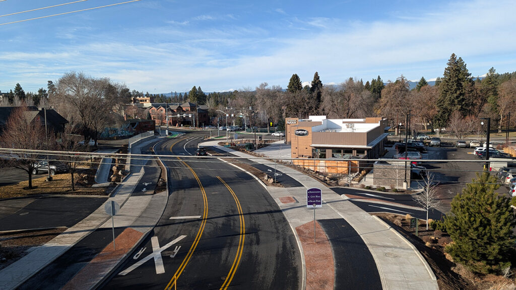
Olney Avenue has fully re-opened to traffic. Construction on Olney Avenue east of Wall Street to Second Street is nearly complete. Some landscaping work will continue in spring 2026.
This project is replacing aging water and sewer infrastructure, and will also make it a safer road to drive, walk, bike and roll.
A 2020 Transportation GO Bond Project.
Thank you, voters!
Olney Avenue connects to schools, parks, trails, businesses and more — places that kids, parents, commuters and others in the City traveling east to west need to reach. But it’s a tough stretch to safely travel when walking, biking or rolling (i.e., using a wheelchair or other mobility device) — which also makes it a stressful route to drive.
Project Updates
Olney Avenue is open to traffic. Some landscaping work will be completed in spring 2026.
This video explains navigating protected intersections.
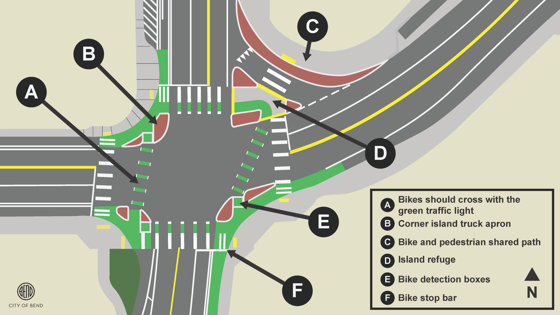
The graphic below illustrates key features of the newly retrofitted Olney and Wall intersection, highlighting innovative design elements that reduce collisions, improve visibility, and boost awareness and safety for all road users.
Vehicles
- The corner island truck aprons are made to slow down traffic and increase visibility for cyclists and pedestrians. Cars should not drive over the top of the corner island truck aprons.
- Vehicles must yield to cyclists and pedestrians before turning right on green.
Cyclists
- If the traffic light is red, cyclists should wait in the bike detection boxes for the signal to detect them.
- Cyclists can cross the intersection when the traffic light is green.
- Cyclist should cross in the same direction of travel as vehicles.
- To turn left, cyclists should stay in the designated bike areas and make a two-stage left turn.
Planning Your Route:
Here is an alternative routes map that could potentially help you get around town easier. Some potential east-west routes you can take are:
- Mt. Washington Drive and Butler Market Road on the north end of town
- Newport Avenue and Greenwood Avenue through downtown
- Franklin Avenue through Downtown
- Reed Market Road on the South end of town
The Olney Avenue Pedestrian and Bicycle Improvements Project’s goal is to solve two issues at once:
- Replace the aging water, sewer and stormwater infrastructure to keep up with the needs of our community.
- Upgrade the roadway to make it safer for all users of the road.
The Olney Avenue project is part of the 2020 voter-approved Transportation General Obligation Bond. This stretch of road was identified by the community as a key route to create better east-west connections across the City.
After gathering input from the community, the Transportation Bond Oversight Committee (TBOC) made a recommendation to the Bend City Council to complete the Greenwood Avenue Pilot Project before the Olney Avenue Pedestrian and Bicycle Improvements Project. This recommendation was approved by the Bend City Council.
Oregon state law requires that cities provide a viable detour route for all modes of travel. This means we must have a detour route that can be used by drivers, walkers, bikers and rollers. This is why changes and safety improvements were made to Greenwood Avenue uses first, so when the Olney Avenue and Wall Street intersection closed, Greenwood could be used as a safe detour route by all users of the road.
Through research and data collection it was determined that the original four-lane configuration of Greenwood Avenue was not safe and a viable detour route for drivers, walkers and bikers which led to the pilot project and the changes that you see on Greenwood today.
The Oregon Transportation Safety Data Explorer reports 77 crashes in the project area from 2017-2022. The corridor was dangerous to cross safely, drivers were exceeding the speed limit with backups due to cars waiting in the left-hand travel lane to make a left turn. Going back to a four-lane configuration on Greenwood would mean eliminating the center turn lane. Estimates in the first Greenwood Traffic Monitoring report suggest that motor vehicle travel times through the corridor are similar to what they were prior to the pilot.
Much of the more recent traffic we have experienced was due to the timing of a snowstorm and the closure of the Olney Avenue and Wall Street intersection occurring at the same time. The hope is that traffic conditions will improve with the weather.
We understand that these changes are frustrating and recognize the impacts they have caused. We have worked with the Oregon Department of Transportation (ODOT) to lengthen the time that traffic signals are green on Greenwood Avenue heading east and west to allow for more traffic flow. We are going to continue to monitor traffic due to the closure and do what we can to help lessen those impacts.
We want to thank the community for their understanding and patience while we work to upgrade our aging infrastructure and City streets not only so they can function properly now but for years to come.
What route does the City of Bend recommend for large trucks and delivery vehicles accessing businesses on Second Street between Olney Avenue and Greenwood Avenue?
Second Street is designated as a low-stress route for bicyclists and pedestrians, and the City has been investing in improvements along this corridor to increase safety and comfort for these users. The intent is to discourage higher vehicles volumes and calm traffic to promote non-vehicular travel along Second Street. Vehicles, including delivery trucks, are intended to use First Street and Third Street as the primary access routes to businesses along Second Street. Left turn movements are allowed approximately 300-ft away on all roadways surrounding Second Street. Second Steet is still designed to allow for right turning vehicles in and out.
Were truck access and delivery logistics considered in the final design of Olney Avenue/Second Street?
Yes. As part of the traffic study in 2023, we looked at the trade-offs of closing the left turns to Second Street and the increase of traffic on First Street and 3rd Street. Additionally, truck access and delivery movements were evaluated during design using truck turning software to confirm that trucks can utilize First Street. Curb painting is being added around the First Street intersection to limit parking too close to truck turning paths.
The closure of left turns at Second Street creates a safer crossing for pedestrians and bikes. A safe crossing at this intersection was a priority of the Transportation General Obligation Bond voted on by the community in 2020. We also went through a public outreach period in 2023-2024 and heard this was the preferred design from the community.
First Street is classified as a local street so trucks should use Third Street or Olney Avenue to get as close to their destination as feasible. First Street is approximately 35-feet wide with parking allowed on both sides and is intended to function as a queuing street, which encourages slow and cautious driving behavior and often requires one vehicle to pull over to allow opposing traffic to pass.
Are there any planned improvements to Norton, Lafayette, or surrounding streets to support their increased use as primary access routes?
Yes. The City is planning to perform significant pavement improvements on Norton Avenue from Second Street to First Street as soon as weather conditions and the nearby construction allow. We recognize that Norton Avenue has been in poor condition and that construction activity has contributed to its deterioration. Unfortunately, we could not make major improvements on Norton Avenue while Olney Avenue was also closed this past year. Pavement activities can usually take place on 40-degree and higher weather days, so we are eyeing the weather and our crew’s availability for upcoming Norton Ave improvements. Other pavement improvements on additional streets in this area will be analyzed and addressed as needed.
Construction Questions
Who will be responsible for constructing and managing the project?
The City of Bend is responsible for owning, inspecting and managing the project. K&E Excavating Inc. has been selected as the project’s construction contractor who is responsible for constructing the project in accordance with the City’s project plans and standards.
What are the potential traffic disruptions of the project?
Olney Ave will be closed to through traffic between Wall Street and NE Second Street. Drivers should be prepared to use detour routes that include Newport Avenue, Greenwood Avenue, Ne Third Street, Revere Avenue and southbound US97. Access to all businesses will remain open but may have detour business routes.
How will I access businesses on Olney Ave?
Access to all business will remain open during construction. However, there may be temporary detour routes to access businesses around the active project construction areas. Sections of Olney Ave will be completely closed as necessary during construction. There may be times that you can access a business from Olney Avenue, but drivers should also be prepared to use a detour route if the business is in the middle of an active construction zone. The City will have business access detour routes signage for the public to follow from all directions. Please reach out to the project team if you have specific questions on business access before or during construction.
How will deliveries and trash pickup be impacted?
Delivery & trash pickup will remain as normal during construction. The City will coordinate with the Post Office and garbage services during periods of limited access. The City is required to always provide one point of access to a business/lot, and we will share information on temporary detours and access plans with services and businesses.
Why are we replacing sewer and water pipes?
Water and sewer line work is essential to replace aging pipes, meet the demands for growth in Bend and potential emergencies, create a flexible system, and to prevent future ruptures. These lines are from the 1950s and 1970s and are needing upsizing and upgrades to current standards. Both pipes run underneath the railroad and require extensive horizontal tunnel boring under the rail to be replaced.
What other projects are happening on Portland Avenue – Is this all one project?
Three other projects are occurring simultaneously during the Olney Ave project in near proximity. These include the Awbrey Waterline Project, which will provide water distribution system upgrades to the Awbrey Butte area, Portland Avenue Corridor Improvements Project, which is providing transportation safety improvements, and the West Side Pump Station Project, which will provide needed electrical and sewer pump station improvements.
These projects are being completed at the same time, to minimize future construction impacts to the area. Visit bendoregon.gov/olney-portland-wall for links to each project website.
Design Questions
Why are we putting in dedicated bike lanes on Olney Ave?
The Olney Ave improvements for new bike lanes tie back to Olney Avenue being identified in the City as 1 of 12 ‘Key Walking and Biking Routes’ in the Transportation System Plan. These routes are designed to be the safest walking and biking routes in Bend with the highest amount of protection for users from vehicles. One can think of these routes as the main highways for people walking and biking. Olney Avenue is one of the only east-west routes we have in town, especially on the north side of town. We measured over 300 people walking and biking on Olney Ave in one day in May of 2023, and we expect to see this number to grow with the project safety improvements.
Why is the City of Bend building so many bike routes?
Bicycle route improvements were identified as needed by the community of Bend on Olney Avenue and other Key Routes in the 2020 Transportation System Plan (TSP). Following that, Bend voters passed the 2020 Tranportation General Obligation Bond (GO Bond) to fund specific improvements identified in the TSP.
Why is the City focused on pedestrian and bicycle safety improvements?
In the United States, the number of traffic crashes involving a bicyclist or a pedestrian has been steadily increasing since 2009. From the 2019 City of Bend Transportation Safety Action Plan, data shows that a cyclist dies or is seriously injured in 1/14 crashes with vehicles. A pedestrian dies or is seriously injured in 1/4 crashes with vehicles in Bend. These statistics paint the picture for the risks associated with known safety issues for vulnerable users, like cyclists and pedestrians. In comparison, vehicle only crashes, have a 1/60 chance of resulting in a fatality or serious injury. At the City of Bend, we aim to design for no crashes on our roads and pay special attention to crash trends involving high risk of a fatality or serious injury.
Do bike lanes cause vehicle traffic congestion?
Studies have found that no, bike lanes alone do not cause more traffic congestion. In fact, studies show that dedicated bike lanes improve traffic flow for everyone as bicyclist and vehicles are no longer traveling in the same lane. Adding dedicated bike lanes has shown to make people feeler safer and increase the number of people biking, therefore reducing the number of cars on the road and improving vehicle traffic congestion.
In an urban environment like Bend, it is very difficult to find the space for additional vehicle lanes without large impacts to businesses and homes. Increasing car lanes doesn’t necessarily reduce traffic and can often worsen it. This is called “induced demand”, where roads are widened, leading to more people driving, and the cycle of traffic continues. At the City of Bend, we evaluate all modes of transportation to build infrastructure that will serve our future population.
Why is the Wall Street and Olney Ave intersection designed like that?
This intersection was designed to reflect newer design philosophies to enhance pedestrian and bicyclist safety. This intersection gives a dedicated space for all users (pedestrians, cyclists, vehicles, etc.) to move through the intersection and complete turning movements. The intersection is based on a ‘dedicated user intersection’ design. More information can be found here: Dedicated Intersections | National Association of City Transportation Officials. A fully protected intersection design did not fit in the existing space and budget for this project; thus, a dedicated user intersection was selected for the design.
Location
Portland Avenue to Olney Avenue starting at the Deschutes River bridge through Wall Street, 1st Street, and ending at 2nd Street.
Public Meetings
Thank you for visiting! Review the exhibits below to:
- Learn about the project construction schedule*
- Know what to expect during construction, including street closures and detour routes
- Learn more about the Olney project improvements
*Dates are estimates and subject to change.
Project Overview
Olney Avenue project improvements will be constructed both above and below ground between the Portland Avenue bridge and NE Second Street.
Schedule and Road Closures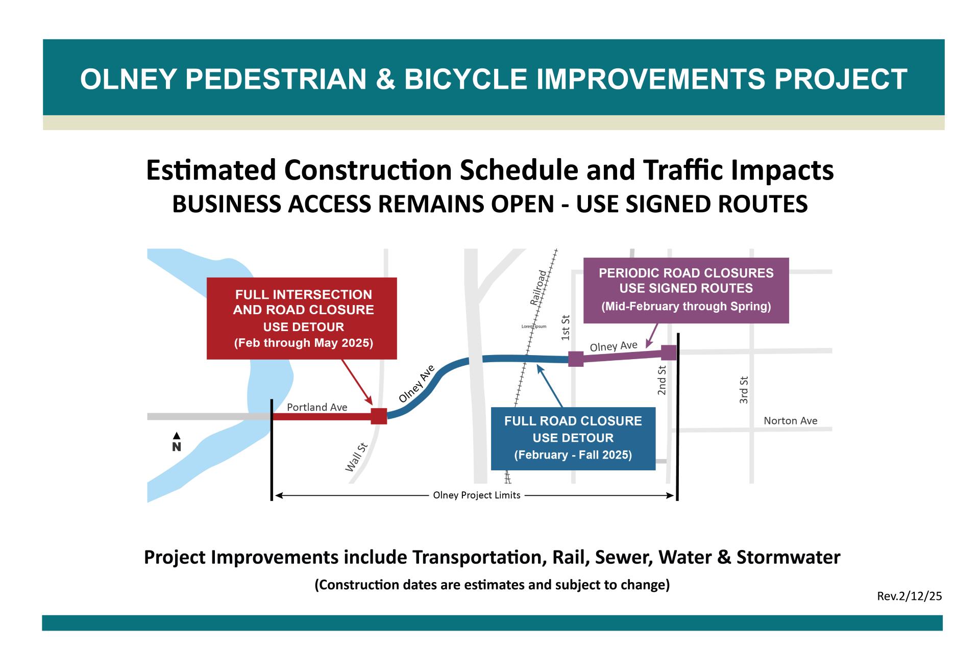
Crews are gearing up to begin construction as early as February 3 with estimated completion in fall 2025. Expect traffic delays, road closures and detours. The construction will include several sections, dates and impacts:
- Full closure of the intersection of Wall Street and Olney Avenue is required beginning in February through spring.
- No through traffic will be allowed on Olney Avenue east of Wall Street through NE Second Street, except for select business access routes.
- Full closures of the Olney Avenue and NE Second Street intersection is required in both spring and summer.
- Business access will remain open during construction. Alternate routes may be required.
Detour Routes – Plan Ahead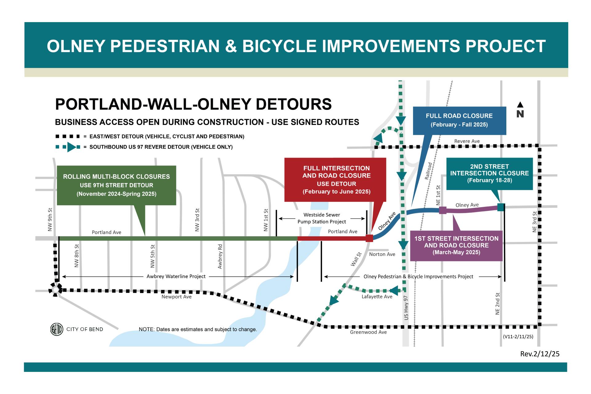
Traffic detours will begin as early as Monday, February 3 and include:
- NW Ninth Street, Newport Avenue, NE Third Street, Revere Avenue and southbound US97
Business Access
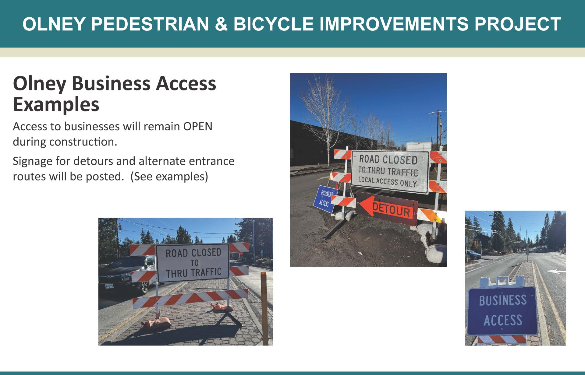
Signage for detours and alternate entrance routes will be posted.
Other Construction Projects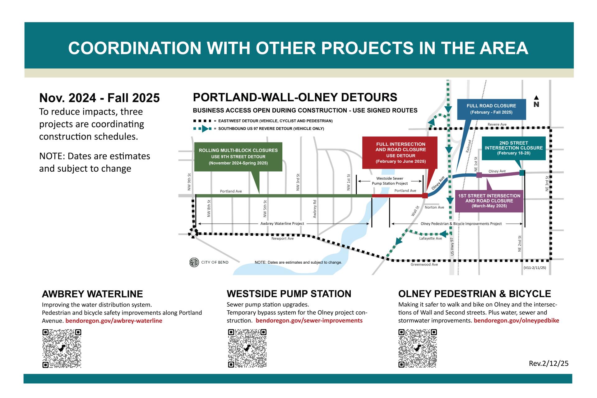
To reduce impacts, three separate construction projects are coordinating schedules for construction occurring along Portland Avenue, Wall Street and Olney Avenue.
Scan the QR codes above or visit bendoregon.gov/olney-portland-wall and link to each project’s website for more information.
Pedestrian and Bicycle Improvements
Click on the image below to view the Olney project areas with the final designs of project improvements.

Thank you for visiting the pre-construction open house!
Questions or Comments?
Click on the Frequently ask Questions tab below for project question and answers. Please use the comment form to submit your comments or questions to the project team.
Sign up to receive project updates in your email inbox.
Project Contacts
Project Manager: Carrie Harris
Project email: olneypedbike@bendoregon.gov
Project phone: 541-322-9919
Interested in learning more about this project?
Review the project background and more details below.
PREVIOUS OPEN HOUSES
Click on tabs below to link to exhibits and information from previous Olney project open houses.
The April 2024 online open house was held to share updated information, address feedback from the July open house and inform community members of the final design and construction improvements. Community members had the option to leave comments and let the project team know what they thought of the final design. A total of 72 people participated in the online survey. Key overall themes in project-related comments are below.
- Most respondents (68%) selected “Yes” when asked whether they think the final design improvements will increase safety for the community. Many commented that they appreciate the new safety improvements for all users on Olney Avenue including physical barriers for walking and biking.
- Respondents had concerned for congestion delays due to limiting left turns. A quarter of the respondents who left comments cite a need for retaining both east and west bound access to Riverside Animal Hospital.
Project Team Response: Project improvements include median placement along certain segments of the corridor weighing street standards, safety of all users, business access, emergency services response and utility service access. The project includes mountable medians in the design where possible.
This open house and comment submittal period is closed. However, you are welcome to browse the open house information using the link below to browse the latest designs to make Olney Ave. safer for walking, biking and driving.
The July 2023 bilingual online and in-person open house and survey informed community members of potential improvements, displayed three project design alternatives, and gathered community feedback with interactive exhibits and a survey. In addition to collecting feedback, the open house covered project-related topics, including project background information and evaluation criteria, pedestrian and cyclist connections and proposed improvements, intersection proposed improvements, safety concerns and countermeasures, and comparison in anticipated cost of different design alternatives. The City engaged and collected feedback from 100 community members in the July 2023 project open house. Key overall themes in project-related comments and responses are below.
- The top project priorities expressed for Olney Avenue in the open house survey were the following:
- Safer and more comfortable places to bike (78% supported as a top 3 priority),
- Improvements at the intersection of Olney Avenue and Wall Street (52% supported as a top 3 priority),
- Safer and more comfortable places to walk (48% supported as a top 3 priority).
- Open house participants expressed a strong desire to feel protected when biking on Olney Avenue. They have concerns specifically when on curves, and crossing intersections like Wall Street, Second Street and First Street.
Project Team Response: We are looking to incorporate grade-separated bicycle lanes along the key route to provide additional protection for bikers with a vertical curb between the bicycle lane and vehicle travel lane. We are looking to design the intersections as dedicated user intersections with safe crossings and dedicated paths for people biking and walking. - The Wall Street and Olney Avenue intersection got the most feedback as a place where people do not feel safe traveling. Making turns here and riding a bike through this intersection was reported as being especially stressful, specifically the westbound right-turn slip lane. People shared frustration with the signal not detecting bikers. Pedestrians on the northwest corner of the intersection do not feel visible to vehicles when waiting and crossing.
Project Team Response: We are looking to design this intersection as a dedicated user intersection with protection for vulnerable users (people biking or walking) inside of the intersection where possible. Protection for vulnerable users could include median crossing pedestrian refuge islands or intersection corner wedges to provide a queuing area for people on bikes, help prevent high-speed turns, and improve visibility of users.
- The shared-use path and protected bicycle lanes alternatives received the most support from participants, with a shared use path being generally more favored than on-street bike lanes. Most participants had concerns with details and connections of these improvements. A on-street bicycle lane “protected” with flexible tubular markers wouldn’t feel protective to some people and could lead to added maintenance costs. Few people said they would use a shared-use path if it’s not well connected to other routes and easy to reach. The shared-use path was generally more favored than on-street bike lanes, but participants expressed concern about different users sharing the same space- such as people walking, running, biking and e-biking on the same path and in different directions. Additionally, there were concerns of shared space between people driving and biking in on-street bike lanes.
Project Team Response: At this time, we are not planning to move forward with a bi-directional shared-use path or on-street bicycle lanes. Instead, we are still planning to meet the project goals and intent by designing to have complete sidewalks and one-way, grade-separated bicycle lanes that allow bicycle movement in one direction on each side of the road. Thus, each user- vehicle drivers, cyclists, and pedestrians- each have their own dedicated travel space to move at a comfortable and safe speed in both the east and west direction.
- A few businesses/landowners along the project corridor commented on prioritizing vehicle access to their properties on Olney Avenue from both the east and west direction. There is concern from businesses that adding new medians on Olney Avenue will cause access issues and negatively impact business. Continual business access during construction was expressed as critical to operations.
Project Team Response: Median placement along the corridor is being considering very carefully weighing safety of all users, business access, emergency services response, and standards that call for a median treatment on certain segments of road, like near a railroad crossing. The project team is considering mountable medians in the design where possible. We will continue to update and work with business along Olney Avenue for the duration of the project for coordination around business needs and potential impacts. - Participants expressed the importance of the connection to the Deschutes River Trail and trail crossing on Portland Avenue.
Project Team Response: Project improvements for Olney Avenue are being coordinated to tie into the Deschutes River Trail crossing at Portland Avenue and additional safety improvements such as signage, crossing location, striping, and illumination are being considered for the crossing. - For traveling on Olney Avenue, 46 participants selected that they drive, 42 participants selected that they bike, 22 participants selected that they e-bike or scooter, and 15 participants selected that they walk. Over half of participants indicated that they would like to use Olney Avenue in the future for daily commuting by biking, walking or rolling.
Another project open house is planned for the spring of 2024. Sign up for project email updates below to be notified about details of the next open house.
Background
Olney Avenue was previously identified in the City’s community-driven TSP update undertaken between 2018- 2020 as a key walking and bicycling route. The TSP was adopted by Bend City Council and projects from the TSP were included in the transportation general obligation (GO) bond passed by Bend voters in November 2020. In 2021, this project was highly prioritized by the Transportation Bond Oversight Committee.
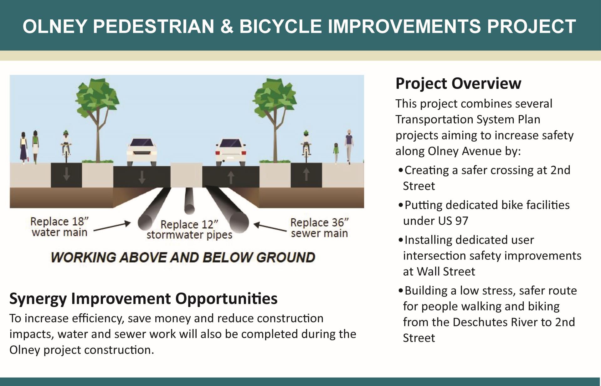
This project combines several Transportation System Plan (TSP) projects aiming to increase safety along Olney Avenue by:
- Creating a safer crossing at NE Second Street
- Putting dedicated bike facilities under US 97
- Installing dedicated user intersection safety improvements at Wall Street
- Building a low stress, safer route for people walking and biking from the Deschutes River to NE Second Street
Synergy Improvements
To increase efficiency, save money and reduce construction impacts, water and sewer project work will be completed during the Olney construction.
- Waterline work is essential to replace cast iron pipe installed in the 1950-70s and prevent future pipe ruptures.
- Sewer improvements are identified as a project in the City’s 2014 Wastewater Collection System Master Plan to replace and upsize existing pipe segments to support Bend’s growth.
- On Portland Avenue between the Deschutes River and Wall Street, some improvements from the GO Bond’s Portland Avenue Corridor Improvements project and Awbrey Butte Waterline Improvement project are being included with the Olney Pedestrian and Bicycle Improvements project construction.
Funding
The Olney Project is funded by the Stormwater, Water, Water Reclamation (Sewer), Transportation and 2020 Transportation GO Bond Capital Improvement programs. The total project funding is $17 million; approximately $6 million is for utility and surface improvements at the at-grade railroad crossing on Olney Avenue.
Visit the GO Bond Dashboard for the latest budget information for this and other GO Bond projects.