Speed Radar Program
The City of Bend and the Neighborhood Districts are working together to provide driver speed education and encouraging drivers to follow the speed limit.
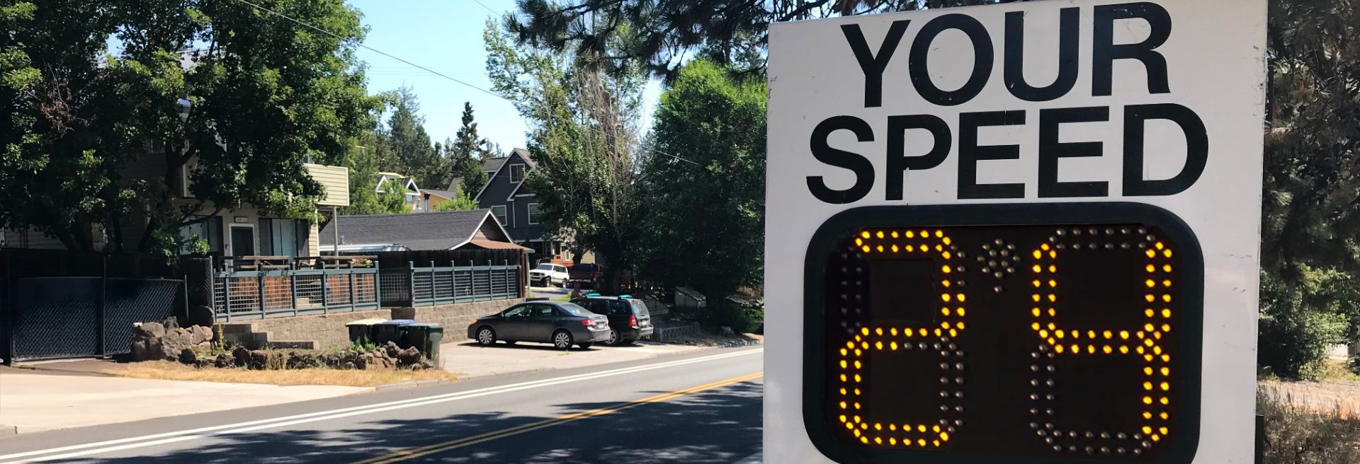
The Neighborhood Speed Radar Program has five mobile speed radar signs that move to different neighborhood streets from May through October, weather dependent. These signs help teach drivers to follow the speed limit. They show the speed of approaching vehicles, letting drivers know if they are going too fast or if they are within the limit. The signs also collect data on speed and traffic volume, which is displayed on the Neighborhood Speed Radar map.
This program supports the Bend City Council’s goal to make streets safer. The Neighborhood Districts help guide where the radar signs go in their neighborhoods. The signs stay at each spot for two to three weeks.
Reasons to Slow Down in Bend
- Slower traffic makes it easier to pull in or out of driveways, cross streets, make turns or ride in bike lanes.
- Slower driving greatly reduces the severity and damage in case of a crash.
- Modifying infrastructure to reduce speeds is expensive, but driving the speed limit is inexpensive.
- Slower speeds increase visibility and require shorter distances to react and stop.
- 70% (600 miles) of our streets are local streets with speed limits of 20-25 MPH.

How We’re Encouraging Safe Driving
Education: We work with neighborhood districts to prioritize speed radar locations, so drivers are reminded of speed limits and encouraged to drive the speed limit.
Engineering/Infrastructure:
- Neighborhood Street Safety Program: In response to requests for smaller street safety projects, the City Council approved funding for the Neighborhood Street Safety Program in 2019-2021. This program builds projects with sidewalks, crosswalks and traffic calming features to slow speeds and improve walking and biking options.
- Travel Options: The City is building complete streets that provide different options for people to walk, bike, take transit, or drive to travel throughout the community.
- Street Design Standards: Street designs include curb returns, parking, narrower streets and median islands that require slower speeds to navigate.
Enforcement: Due to the high number of neighborhood speed complaints, the Bend Police Department Traffic Safety Unit uses a data-driven approach to address its goal of citywide traffic safety and crash reduction. The police department uses information from this program, along with other factors, to prioritize responses to speeding complaints. They consider the 85th percentile speed data, previous crash information, and vehicle volume per day. A higher 85th percentile speed with very low traffic volume and no previous crash data may not meet their enforcement criteria.
How You Can Help Reduce Speeding
- Drive the speed limit yourself. Make a conscious choice to know and follow the speed limit each time you drive.
- Put your cell phone out of reach when in the car – driving distracted is unsafe and against the law.
- Create a culture of speed awareness on your street by talking with your neighbors, family, friends and coworkers about driving the speed limit.
- Allow yourself time to drive the speed limit. Driving even 5 miles per hour slower only takes a few minutes more for a cross-town trip.
Explore the Data
The map below shows where radar locations have been and where they will be next. Click on a point on the map to see the speed and volume information for that spot. Here’s what the data includes:
- Location/Direction: Where the radar was placed and the direction of travel for the data collected.
- Speed Limit: The posted speed limit for that area.
- Time Period: The dates when the radar was placed and removed.
- Average Daily Traffic: The average number of vehicles per day passing that location in the counted direction. The table below shows typical traffic volumes for different street types.
| Vehicles in One Direction Per Day |
Total Vehicles in Both Directions Per Day |
|
|---|---|---|
| Local Street | 250 – 1,000 | 500 – 2,000 |
| Collector | 2,500 – 8,000 | 5,000 – 16,000 |
| Arterial | Greater than or equal to 8,000 | Greater than or equal to 16,000 |
- 85% Speed: The speed at which 85% of cars are traveling at or below, and 15% are traveling above. This is a common traffic standard to evaluate vehicle speed.
- Average Speed: The average speed of all vehicles recorded during the time period.
- Total Vehicles Counted: The total number of vehicles registered by the radar.
Speed Radar Locations
The map below allows you to view speeds and volumes from previous radar sign deployments. Click on each point for more information about the speed radar at that location.
Getting a Speed Radar on Your Street
Before you request a speed radar, review Things to Consider Before Requesting section below, then submit your request to your Neighborhood District. Each Neighborhood District prioritizes locations and makes requests to the City. Radar locations are assigned to ensure coverage in every neighborhood district. With radars deployed in two to three-week sessions from May through October, each Neighborhood District typically gets up to three locations per year.
Things to Consider Before Requesting
- Mounting the Sign: Each sign needs an existing signpost. If there’s no signpost available, a trailer unit might be used if there’s an on-street or shoulder location to park the trailer out of the travel lane.
- Suitable Streets: The program targets local City streets that are more than three blocks long and serve as main access points into neighborhoods from arterial or collector streets. Candidate streets may also have through traffic or be arterial/collector streets with residential homes fronting the street.
- Equality: The program aims to evenly distribute speed radars throughout the Neighborhood Districts on a first-come, first-served basis. If your neighborhood has had several requests served, another location in a different neighborhood might be given priority.
Ready to Request a Radar?
To request a speed radar, email your local Neighborhood District chair with a specific location, direction preference, and issue. For example: “Please install a radar on eastbound Abbey Road just west of Penny Lane on the no parking sign. People are speeding as they cut through to the shopping center.” The Neighborhood District will prioritize and submit requests to the City. Radars are placed between May and October.
For information about each Neighborhood District, including how to find which one you live in and who to contact: